Tram in Osnabrück, Germany
05.2026
Intoduction
While researching tram vehicles manufactured by the Hannover-based company HAWA, I came across the Osnabrück tramway system, which had acquired such vehicles from Hildesheim. The Osnabrück tramway operated from 1906 to 1960. It comprised up to three lines, which were initially designated by the colors blue, red, and yellow. Later, they were renamed Lines 1, 2, and 3.
All essential information regarding the Osnabrück tramway can be found in the excellent book:
Die Osnabrücker Strassenbahn
Alfred Spühr and Claude Jeanmaire
Verlag Eisenbahn, CH-5234 Villingen, 1980
ISBN 3 85649 043 4
In my view, the Osnabrück tramway and Mr. Alfred Spühr form an inseparable entity. Mr. Spühr is an immensely friendly, communicative, and—at the same time—incredibly knowledgeable individual. In this way, he sparked my interest in the Osnabrück tramway, extending beyond my initial connection to HAWA. His aforementioned book impressed me with its meticulous photographic documentation; he precisely pinpointed the location of every photograph by cross-referencing it with the route maps of the three lines. This prompted me to ask myself: what does the area look like today? Or, more specifically: exactly where in Osnabrück were tram tracks once laid?
Objectives of the Interactive Route Map Project
- Supplementing the reading of Mr. Spühr´s book
- Identifying the route alignment within the contemporary urban landscape
- Visualizing the historical evolution of the tram network
Technical Implementation
Thanks to Mr. Spühr’s book and his extensive personal guidance, I had the substantive foundation for the project at my disposal. To capture time-dependent geospatial data, I familiarized myself with the open-source program QGIS (qgis.org). This tool allows users to draw arbitrary georeferenced elements and assign them a specific time span during which they existed. I used the freely available OpenStreetMap (openstreetmap.org) as my "drawing base." This is a global mapping resource created and maintained by volunteers.
From QGIS, one can export temporal sequences as a series of images and—for instance, using software such as GIMP—generate animated GIFs:
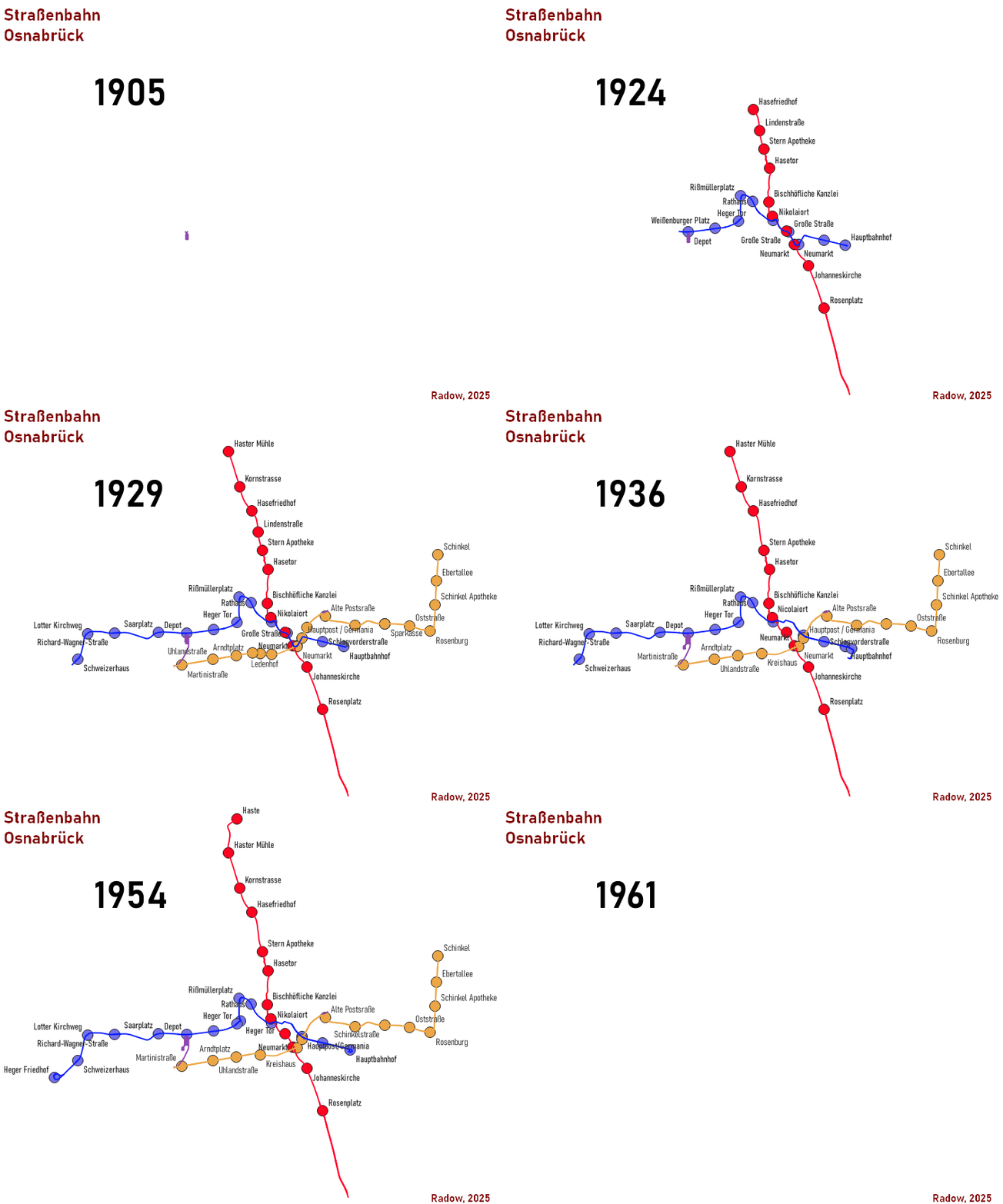
Osnabrück Tram Network Map: Development (shown here from the early stages of the project work)
However, such animations have a resolution that is too low to display all the details drawn in QGIS. The open-source program Leaflet.js makes it possible to integrate interactive maps into websites. For this purpose, the base map is retrieved online from OpenStreetMap. By zooming and navigating, users can freely select the map extent and display scale. I was able to extract the route data for the Osnabrück tram system from QGIS and prepare it for use with Leaflet. I personally programmed a "time navigator"—along with buttons for manipulating the map display—using JavaScript.
Additionally, Mr. Spühr generously made available various photographs—either taken by him or held in his personal collection—that truly bring this map to life. Currently (as of May 2026), the 24 images associated with the Blue Line are available for viewing; images for the other lines will follow..
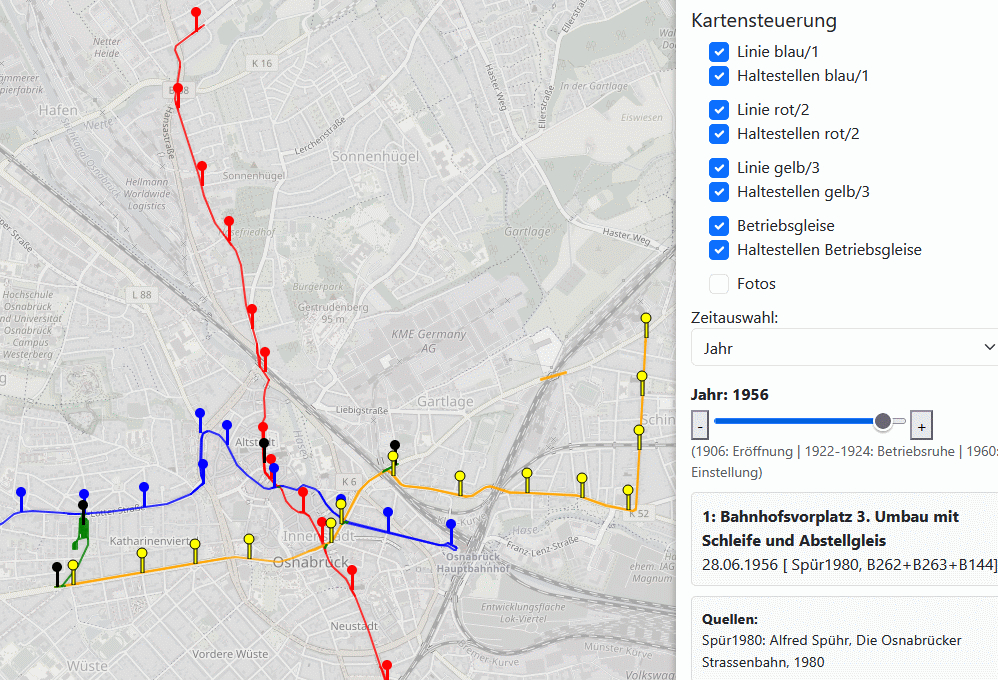
Screenshot of the web interface for navigating the Osnabrück tram route map.
Click on the image above or here to access my interactive map of the Osnabrück tram system.
Using the Map
Map Controls
- Check/uncheck the corresponding boxes to toggle the display of the following elements:
* Lines
* Stops
* Photo Locations
- Move the time slider to change the displayed year
- Advance/rewind by exactly one year using the + and - buttons
Map Navigation
- Pan map view: Move the mouse while holding down the left mouse button
- Zoom: Click once on the map; scroll the mouse wheel up/down
The following functions are enabled only when you have zoomed into the map far enough for the year labels to appear next to the photos
- Stop Information: Hover the mouse cursor over a stop
- Photo Preview: Enable photos via the checkbox + hover the mouse cursor over a photo icon
- Full-screen Photo: Enable photos via the checkbox + click on a photo icon
Information Accuracy
Historical maps—such as the historical Messtischblätter (TK25 topographic sheets) at a scale of 1:25,000—do at least provide an indication of the Osnabrück tramway´s track layout. Historical city maps offer no greater degree of accuracy. I have not been able to locate any higher-resolution historical topographic sheets for Osnabrück—such as those available for Hanover at a scale of 1:1,000.
Various original documents were used as heating fuel by the British Army during their occupation of the tram depot. Mr. Spühr documented essential information regarding the track layout of the Osnabrück tramway in his book. During Mr. Spühr’s research activities—conducted prior to the closure of the Osnabrück tramway in 1960—photocopiers did not yet exist. Consequently, he was obliged to limit the scope of his hand-drawn sketches and transcriptions to the most essential details. Mr. Spühr later discovered that Stadtwerke Osnabrück AG had destroyed the final two filing cabinets containing tramway-related documents due to a lack of storage space.
For these reasons, information is partially missing—for instance, regarding the discontinuation of specific stops, the dates on which superfluous passing loops were dismantled, or even the exact positioning of tracks and switches.
When transferring this historical knowledge onto contemporary maps, it is important to bear in mind that the built environment, street alignments, and intersection layouts have evolved over the years. Due to time constraints—and given the inaccessibility (or indeed, the very existence?) of precise historical maps—I have opted not to depict these specific changes. Furthermore, the freely available OpenStreetMap displays features—such as road widths—in a standardized, zoom-dependent manner, and thus does not always accurately reflect the actual conditions.
Consequently, the route layout I have drawn in OpenStreetMap merely serves as an indication of the track and switch configuration. For instance, passing loops and branch lines may have been situated at slightly different locations (within certain limits). For deeper insights, I highly recommend Mr. Spühr’s richly illustrated book!
Conclusion
Over the evenings and weekends of the past few months, I have learned a great deal about the Osnabrück tramway—as well as the collection, visualization, and presentation of geospatial data. I took particular pleasure in collaborating with Mr. Spühr as a contemporary witness; without him, this project would never have come to fruition—many thanks once again!
As a follow-up project, I have simultaneously begun mapping the Hanover tramway system. I am particularly interested in the freight operations aspect of this endeavor. The excellent research compiled by Messrs. Exner and Moch will serve as my foundation. I would be absolutely delighted to receive any additional historical information regarding ÜSTRA, as well as any kind of photographic or visual material!
Videos
Fortunately, the Osnabrück tram system was also captured on film. I discovered these two "clips" on YouTube. Do you know of any other footage?
"Our Electric" – A Remembrance of Osnabrück´s Tram
Osnabrück: From Tram to Bus
Modell Tram Osnabrück from Alfred Spühr
Unfortunately, this video may not be embedded in external sites, so please click on the text "Watch on YouTube" below and admire it there.
